How should new communities be created and their boundaries defined? Will Deputy Prime Minister Kuleba be able to continue the reform?

Only about 60 communities out of almost 1500 thousand have their boundaries marked on the State Cadastral Map. Preparing the relevant documentation is costly, and it is not even feasible for all communities to do so under the current legal requirements. If the government adopted new rules and did not require such detail in document preparation, several billion hryvnias could be saved in community budgets.
However, community boundaries are not the only issue that needs to be regulated.
Currently, new legislation is needed if communities would like to amalgamate with someone or if a community would like to split into several communities, which is quite possible. The government would have to submit the relevant draft to Parliament. The Ministry of Regional Development should have been responsible for this in the government, but it was eliminated several years ago by merging this ministry with the Ministry of Infrastructure. This was a strategic mistake, as the Holka civic initiative has already been written about in Dzerkalo Tyzhnia.
The state administratively amalgamated several communities in 2020 after 5 years of voluntary amalgamation. The Parliament adopted a resolution “On the Formation and Liquidation of Districts (Rayons).” The law “On Voluntary Amalgamation of Territorial Communities,” which has lost its relevance, regulated such amalgamation.
The question now arises as to whether personnel rotations in the government will help solve these pressing problems.

Currently, to define community boundaries, very expensive land management projects that provide high detail are necessary, which is essentially unnecessary for community management. The defined boundaries of settlements allow the community to build a development strategy. It is the boundaries of communities that define the territory of jurisdiction of local authorities.
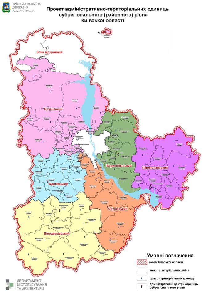
In fact, during the formation of new districts, the government and regional state administrations demonstrated maps with the boundaries of districts and settlements.
However, the state does not see such maps as a real definition of boundaries until they appear on the cadastral map, so land management organizations and, possibly, the StateGeoCadastre should make money here. Boundary delineation and land management projects cost a lot of money, and not every community has the money to do them the way it is done for individuals and corporations — with an accuracy of 20 cm.
Communities definitely do not need such accuracy.
While communities are looking for money, there are ongoing lawsuits over boundaries, and we are talking about a boundary of several thousand hectares rather than a few tens of meters. Take Kyiv and the village of Kotsiubynske, which is part of the capital. Disputes between these two communities have been ongoing for decades. Because of the lack of political will to approve the boundaries of the communities as they are on the map, the development of the communities is hampered, and we lose the resources of the law enforcement and judicial systems.
According to international law, borders are approved on a map with a scale of 1 in 50,000. This is called delimitation. And demarcation, i.e., their mapping on the ground, or as they say, in kind, is the subject of agreements between the parties, who agree on where the border posts should be placed.
Again, there are rules — such a border is to be set within the accuracy of the delimitation map, which allows an error of 60 meters. International law states that the actual boundaries run along the middle of rivers, ravines, and watersheds. Such norms are proposed to be approved in the law on administrative organization. In reality, the boundary marked on the map is described by a set of so-called turning points.
However, the accuracy of determining the coordinates of such points is different for a private land owner/user and for the authorities’ needs. The government determines the scale of accuracy. The government should delimit the boundaries of communities, but it does not want to take on this responsibility.
Dmytro Makarenko, the head of the State Geocadastre, explains in his response to the Holka civic initiative that it is possible to work on a smaller scale:

Pavlo Ostapenko, an expert on territorial development and local self-government, notes that he has long proposed how to do this with minimal costs:

However, the issue of boundaries is not the only one that needs to be addressed. Some communities need to be separated or, on the contrary, united. Firstly, the war makes its own adjustments, and secondly, some communities were created as a political compromise. Sometimes, to receive services, residents of one community have to move to the center of another. That is, a resident of one community uses the social infrastructure of a completely different community.
MP Vitalii Bezghin (Servant of the People) notes that there are indeed several dozen such communities that have become a political compromise and add that the country should receive legislative regulation on changing the boundaries and number of communities before the end of the war:

Adjusting the boundaries of communities helps assess their capacity to provide services to residents. Some communities are too small, either in number or area, and either cannot organize the full functioning of the executive bodies of the council or lack social infrastructure. Thus, as of this year, more than 90 communities have not established their Administrative Service Centers, and these are not the communities located in the center of hostilities.
There are also too-large communities, which make it difficult for them to provide these services in a quality manner.
The main mission of the districts, and there are 136 of them, is the efficiency of management of state bodies, i.e. territorial executive authorities. The ineffectiveness of the functioning of territorial executive authorities will become apparent after the new functionality of district-state administrations is implemented with the adoption of the draft law “On Local State Administrations ” (No.4298). There is also a radical division of powers between central bodies and territorial bodies at the regional and district levels, in particular, the police, the State Emergency Service, and the State Tax Administration. In other words, a reform called deconcentration of executive power.
Ostapenko explains that the previous administrative structure was in place since 1925 under the Bolsheviks:

Parliament appointed Deputy Prime Minister Oleksiy Kuleba, a former deputy head of the Presidential Office who now heads the Ministry of Community and Territorial Development. In this position, he should initiate such legislative changes through the government. This should be a government project, as it determines state policy. It should be considered by the Parliamentary Committee on the Organization of State Power and Local Self-Government.
However, it is extremely difficult for the ministry to prepare a high-quality policy because of the constant merger and separation of the Ministry of Regional Development and the Ministry of Finance. Such processes significantly weaken institutional capacity.
It is also important to emphasize here that the definition of a “community” is not in the law “ On the Procedure for Resolving Certain Issues of Administrative Organization.” This is a basic administrative unit. There are only definitions of settlements – village, town, and city- based on urban planning criteria, not on the mechanical population.
That is why the government has been tinkering with the definition of administrative units:
It should be noted that the Ministry has long prepared a document that could become a legislative initiative but, according to sources, has not yet been submitted for consideration. Finally, the government is not even able to submit to the Parliament a draft law on simple amendments to the resolution “On the Creation and Liquidation of Districts” that would provide for the formation of communities in Crimea.
The delay in legislative support for regulating administrative organizations has already led to lawsuits over what the plaintiffs consider to be an illegal amalgamation of settlements.
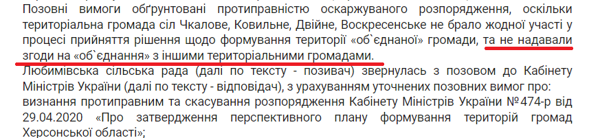
Excerpt from the decision of the district administrative court
But court rulings, if they favor the plaintiffs, cannot be enforced because … the procedure for amending the administrative-territorial structure has not been regulated as a law.
In the end, the main provisions of the document, which should be submitted to the government and become a bill, have already been worked out and are based on the practice of administrative formation of communities and districts in 2020. They stipulate that:
- Changes are made in the form of a resolution of the Verkhovna Rada, not a law because they are one-time acts.
- Drafts are submitted only by the government.
- Changes related to the creation and liquidation of communities are approved by the Parliament, as they involve the creation or liquidation of a public authority. However, changes in the configuration of communities and the removal or addition of settlements are carried out by the government independently, based on capacity criteria.
- Changes can be initiated only by communities or the government, without the involvement of regional and district councils.
- The list of oblasts remains taboo until the Constitution is amended, but the Constitution does not prohibit changing their configuration.
The administrative structure is the skeleton of the state, and the efficiency of the state machine and local governments depends on how well it is arranged. Psychological barriers to changing it were overcome 10 years ago. The current composition of the Parliament made it possible. But whether the MPs will have the strength to complete the legislative part of the system’s regulation is an open question. Partners will not help. We have to rely on our own political will.
Specially for Dzerkalo Tyzhnia